Between the end of Israel’s 1948 Independence War and the outbreak of the June 1967 War, Jerusalem was divided in two: West Jerusalem was under Israeli control and covered about 38 square kilometers, and East Jerusalem was under Jordanian control and covered about 6 square kilometers. Following Jordan's retreat and subsequent Israeli victory over the Jordanian-held territory West of the Jordan River in the war, the Israeli government annexed roughly 70 square kilometers of land to West Jerusalem, ultimately bringing down the walls and fences that had divided the city.
A committee headed by Israeli General Rehavam Ze’evi defined new borders for the city. The Committee Plan, which was approved by the Knesset, included the Old City of Jerusalem and its surrounding residential neighborhoods, as well as slivers of the municipalities of Bethlehem and Beit Jala. The newly expanded city was referred to as a “unified Jerusalem.”
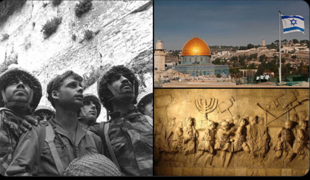
“The Temple Mount is in our hands.” Motta Gur
— RedLehi (@LehiRed) June 7, 2021
The reunification of Jerusalem, June 7th, 1967. The greatest achievement of the modern State of Israel. pic.twitter.com/QvIPxXy9z7
The questions of the civil status of East Jerusalem residents who were primarily Arab and the fate of property they owned on both the east and west sides of the city were interwoven from the very beginning of the discussion around the implications of annexing the Old City and the villages in its vicinity to the State of Israel.
The annexation of the Old City of Jerusalem and 28 villages around it to the State of Israel shortly after the war raised questions about the civil status of the Palestinian inhabitants who found themselves in an area the State of Israel had declared as its own which was the international norm after a defeated army in an offensive campaign retreated from the territory.
In a few hours, we will be proudly marching with Israeli flags in #Jerusalem to celebrate the liberation and reunification of our eternal capital! pic.twitter.com/4Zg9MLlOqQ
— Im Tirtzu (@IMTIzionism) June 15, 2021
Moreover, certain Israeli land and property laws, designed to handle property owned by people who had become refugees or internally displaced in 1948 raised issues around the property of East Jerusalem residents. The Government of Israel was in no rush to resolve the complex issues created by the annexation.
What was ultimately decided was under Israeli rule, the inhabitants of the annexed areas were given special citizenship status. Following a census conducted by the Israeli government, these residents were provided permanent residency status with the option to become full Israeli citizens. However, the majority of these residents never opted to become full Israeli citizens for fear of reprisals against their families who lived in Arab lands.
3,000 years ago, King David made #Jerusalem his capital.
— Israel ישראל (@Israel) May 18, 2020
Later this week on #JerusalemDay, we'll celebrate the reunification of Jerusalem in 1967, Israel's capital and the spiritual heartbeat of the Jewish people 🇮🇱💓#IsraelHeritageMonthpic.twitter.com/1LusTRQekO
The Old City of Jerusalem, which is home to holy sites for Judaism, Christianity, and Islam, was divided into four separate quarters: Jewish, Christian, Arab and Armenian. Prior to 1967, Jordan prohibited most non-muslims from accessing the holy sites, holding a firm grip on it as part of the campaign to Islamify the city to justify their control over it. After Israel’s annexation, all groups were given free access to their holy sites - Muslim, Christians, and Jews alike.
