A newly published study from the Hebrew University determines for the first time, through archaeological and historical means, the boundaries of the kingdom of King David and his grandson, King Rehoboam, and resolves the long-standing debate about the very existence of the kingdoms and their urban boundaries.
A new study by Professor Yossi Garfinkel from the Institute of Archeology at the Hebrew University, which was published in the prestigious "Jerusalem Journal of Archaeology" determines for the first time what the boundaries of the urbanization process and the planning of the early phase of the Kingdom of Judah were during the time of King David and where the central administration of King David's Kingdom was located at the beginning of the tenth century BC and of King Rehoboam, at the end of the tenth century BC.
By mapping the urbanization process starting from the 10th century BCE, this archeological study draws the borders of the earliest phase of the kingdom of Judah as it expanded starting from the reign of King David. Interesting stuff! pic.twitter.com/kw58hRjjdT
— Uri Kurlianchik (@VerminusM) June 26, 2023
Starting around 1980, heated disagreements arose over the historical value of the biblical traditions dealing with the tenth century BC, the time of Kings David, Solomon, and Rehoboam. Some researchers claimed that the urbanization of Judah only began at the end of the ninth century BC, about 200 years after David, and even at the end of the eighth century BC, about 300 years after David.
The new study is of importance to the historical study of the First Temple period, and to the study of the biblical tradition about King David and it proves beyond all doubt the existence of the kingdom.
Archaeological proof of King David's kingdom and Israel dated to 2800 years ago. 🔁 pic.twitter.com/djBxmDAXSU
— Dr. Haim Cohen دكتور حاييم كوهين (@Haim44) June 23, 2023
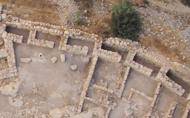
The way in which David's kingdom was defined is through a group of cities in the form of "fortified walls" which are established only on the perimeter of the kingdom and protect a main road to the heart of the kingdom. Fortified walls have been found over the years at a number of sites that correspond to biblical accounts of cities such as Bet Shemesh, and now, as Professor Garfinkel found in his research, these walls date back to the beginning of the tenth century BC, the days of King David's reign, and they teach us where the Kingdom of Judah extended during his reign. It is worthwhile to note that the composition and architecture of these walls, though scattered around, are similar meaning the design for them was established by one entity and that is believed to be, according to the study, David's Kingdom.
According to the research, the borders of the kingdom were at the ruins of Kyapa, which sits on the Elah Valley road, the western end. Beit Shemesh, sits on Nahal Sorek Road, at the northwestern end. Tel Netzva, on the main road on the side of the Samaritan mountain, which sits on the northern edge, and the ruins of Dawwara close to modern-day Nablus, which sits on the northeastern edge. The location of the walls and the way they were built teaches us that in the days of King David, it is possible to find a strong central government, with a clear concept and urban plan that delineates the central borders of his kingdom with thought and intention first.
#Archeology Continues to Confirm #Biblical Record
— Breakpoint (@BreakpointCC) June 20, 2023
New evidence is confirming the biblical description of the kingdom of Judah as it existed in King David’s time.
Read the full article: https://t.co/cbJ9mh4Lhn#Christianhistory #history #KingDavid pic.twitter.com/kHH2B8bCfo
Also, the research found that during the time of King Rehoboam, at the end of the tenth century BC, the Kingdom of Judah grew and it includes additional urban centers, some on the back of the mountain, and some in the north and central lowlands.
