In a move that underscores Israel’s commitment to technological innovation and national self-reliance, The Israel Survey Center (Hebrew Acronym: MAPI), a government agency has announced its intention to develop a cutting-edge navigation platform that could rival global powerhouses like Google Maps and Waze. This initiative represents a significant leap forward in Israel's technological landscape, aiming to create a comprehensive, homegrown solution for navigation and mapping needs.
A Vision for Comprehensive National Coverage
The proposed platform is more than just a mapping tool; it is a strategic national asset. MAPI envisions a robust system that seamlessly integrates a wide array of data, including points of interest, government institutions, road signage, and real-time traffic updates. This initiative is set to redefine how Israelis and visitors navigate the country, offering unparalleled accuracy and efficiency.
MAPI has issued a call for proposals, seeking bids from software developers capable of delivering an off-the-shelf solution that can cover the entire territory of Israel, including the Palestinian Authority. This extensive coverage ensures that every corner of the nation is mapped with precision, allowing for comprehensive navigation queries through a built-in application hosted on government map servers and other official websites.
A Multi-Faceted Tool for National Security and Public Service
The potential applications of this platform are vast and varied. One of its primary functions will be to serve as a critical tool for emergency response teams, enabling them to identify and navigate the quickest routes to incident locations with pinpoint accuracy. In life-or-death situations, where every second counts, this platform could prove invaluable, potentially saving countless lives.
Beyond emergency services, the platform will play a crucial role in updating and enhancing government databases, ensuring that road network information is always current and accurate. This will not only improve the efficiency of government operations but also provide the public with the most reliable navigation data available.
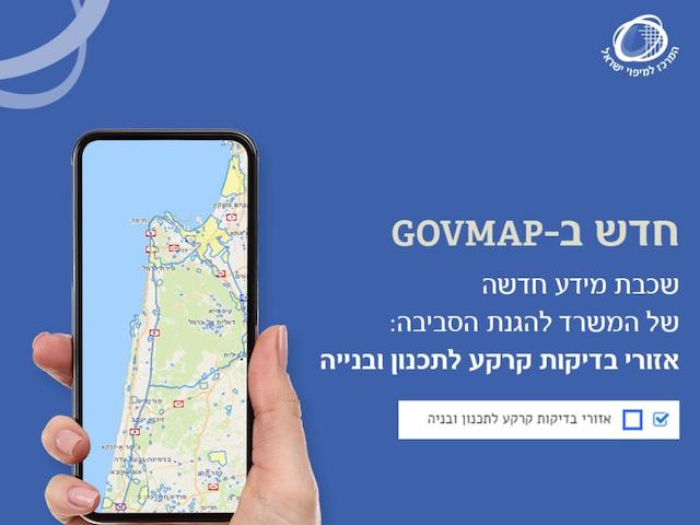
כדי להקל על הליך אישור בקשות לאישורי בנייה, תוך שמירה שלא יהיה סיכון לציבור בבנייה בקרבת אזורים תעשייתיים, המשרד להגנת הסביבה הוסיף שכבה חדשה: "אזורי בדיקות קרקע לתכנון ובנייה". כעת המידע על האזורים בהם יש פוטנציאל לזיהום קרקע ונדרש הליך חקירת קרקע כחלק מהליכי התכנון נגיש ושקוף. pic.twitter.com/oR9mO2mTcn
— מפ"י - המרכז למיפוי ישראל - Survey of Israel (@mapigovil) August 20, 2024
Advanced Features for the Modern User
MAPI is pushing the boundaries of what a navigation platform can offer. The new software will incorporate detailed address information, including street names and house numbers, to ensure users can find any location with ease. It will also offer advanced features tailored to different types of users, such as traffic directions optimized for various vehicle types, data on bridge dimensions, public transportation schedules, and even pedestrian crossing information.
These sophisticated features are designed to meet the diverse needs of all users, whether they are driving, cycling, walking, or using public transport. The Mapping Center is incentivizing innovation by offering bonus points to bidders who propose to include these advanced features, ensuring that the final product is as comprehensive and user-friendly as possible.
Israel is seeking to develop its own Waze: published a tender for navigation software
— CTech (@Calcalistech) August 25, 2024
The Mapping Center is inviting bids for an off-the-shelf software that can cover the entire territory of Israel and the Palestinian Authority. https://t.co/ahX3l4x4Qr
Timelines and Public Accessibility
The timeline for this ambitious project is tight. The deadline for tender submissions is set for the end of September, and the Mapping Center expects the platform to be operational by 2025, pending the evaluation and approval of proposals. Once launched, the navigation services will be accessible to everyone—civilians, government employees, and security forces alike—making it a truly public utility.
This initiative represents a significant step forward for Israel, showcasing the nation’s ability to innovate and lead in the digital age. By developing its own navigation platform, Israel not only enhances its technological sovereignty but also sets a new standard for navigation services worldwide. The world will be watching as this project unfolds, eager to see how Israel’s latest technological endeavor will shape the future of navigation.
